Tucked under Roseville Bridge, this track feels like a local secret. It’s picturesque, it’s a pretty clear pathway and, most importantly, it’s quiet.
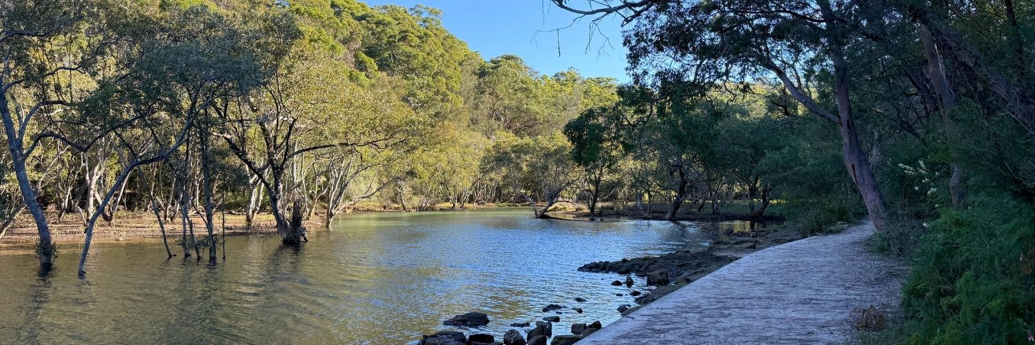
Two Creeks track follows the west side of the water from Middle Harbour to Middle Harbour Creek on a relatively easy riverside walk. Unlike the walk on the east side, which fully sits within Garigal National Park, Two Creeks offers a much nicer experience, in our view. Plus, there’s free parking.

Length of the walk
An out-and-back track, the Two Creeks walk can be as long or as short as you’d like. While the council map above shows the starting point at Tryon Road, you can start at either end. There’s plenty of street parking at the end of Babbage Road near the bridge. We’ve always started at this end.
If you’re hoping to being a dog, you’ll need to start at Babbage Road, and will be limited to about a 7km walk. Half-way to the finish point, the track crossing into Garigal National Park, where pets aren’t permitted.
If you’re pet-free and follow the full All Trails map, you can get up to 13.8km in. There are a few off-shoots, including joining Barrie Street Track toward the Northcote Drive end of the track where you can join onto other tracks in the national park for an even longer walk.
We usually do about 7-10km before in total, walking in about 3.5-5km before turning around. We find the trail tends to get less scenic toward the end as it deviates from the water and gets rougher.
Difficulty
We rate this one about 2.5/5. Both All Trails and Ku-ring-gai Council rate it as Moderate.
Other than a slight scramble under the bridge and pipeline at Babbage Road, the majority of the track is flat, wide and smooth. If it wasn’t for the beginning sections or stairs involved for accessing the track, you probably could ride a bike or push a pram along most of it.
If you’re in for a longer walk though, the track does become a bit more challenging with rocks and climbs once you cross into the national park. We’d rate that section a 3/5 and the first half a 2/5.

Terrain
The section of the walk from Babbage Road to just past the Roseville Bridge can be a bit rough, as there are tree roots and rocks to navigate. Once you’ve passed the bridge, though, it’s pretty smooth sailing.
While not paved, most of the walk from here is smooth dirt. Think of it like a narrower fire trail. There are a few steps here and there, but nothing that should get your heart pounding.
There’s also a small section about 200m long that is a narrow boardwalk, but it’s also flat.

Wildlife and nature
As the walk is very much in the middle of suburban Sydney and popular with dog walkers, there isn’t too much wildlife to be seen around here. Expect some lizards, birds and maybe snakes.
If the water is pretty clear though, you may be able to spot some aqua-life. Moores Creek is full of mangroves, which makes for some cool pictures around the section where the track crosses over. The tidal mudflats around here are home to fish, oysters, crabs, stingrays and more.
Aside from animals, the plant life around here is lovely, and changes along the walk. For the beginning part of the walk and end, you’ll see very much classic Sydney bushland with soaring eucalyptus trees, blackbutts and banksias. But, by Moores Creek, expect to see mangroves and palm trees by the water.
Facilities and amenities
There aren’t any facilities along the track itself, but there are a few lookout points where you can sit on the rocks to take a break or have a small picnic. Unfortunately, there aren’t any toilets available, either. But there are some nearby that you can use. Near the end of the walk, there is a toilet block just a street over at Lindfield Oval. At Babbage Road, there is a restaurant at the marina where you can get food and drink and use the toilet.

Getting there
If you’re starting at the Roseville Bridge end, you can take the 260, 270, 271, 274, 278, 279, 280, 281, 283 or 284 bus. Once you’re off the bus, you can take the Roseville Bridge Walkway, which meets up with the track.
You can also drive and park on Babbage Road or at Lindfield Oval. If you’re parking at the latter, make sure you don’t walk out onto the Eastern Arteral Road, but instead take the left path at the fork toward the oval.
What else do you need to know?
Part of it is. If you’re keen to bring your dog along, make sure you start at Babbage Road. Half-way through the walk, the track crosses into Garigal National Park. There will be a sign at the beginning of the park, which will need to be your turn-around point.